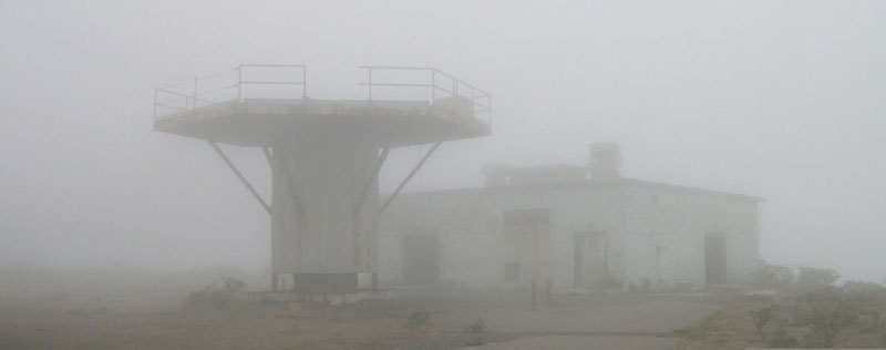
Seems the Odyssey gradually reaches its end. Two days ago, I could discover first traces of the „legend shrouded“ V2 in Muensterland. I was excited to get in touch with Mr. Schaten, who lives nearby Schoeppingen in a small city called Heek. Mr. Schaten guided me to the remains of a concrete launching platform, which has been left in a small forest called „Oer’scher Wald“.
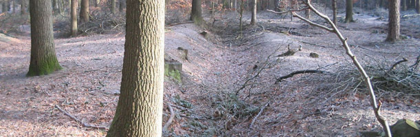
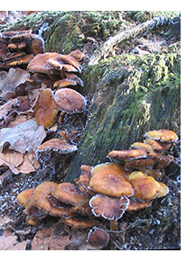 It was a cold, but very clear winter morning, good to walk the normally muddy ground. The whole area is still carved with old trenches and ditches – on some rotting trunks frozen sulfur tufts (Hypholoma fasciculare) were gathering. It looked as if the mushrooms have absorbed the sulfur fall-out from the launching rockets. I also could find several bigger pits in the forest soil which apparently stem from removed platforms – or from crashed V2-rockets. (V2-crashes are reported from several eye witnesses in Western Muensterland)
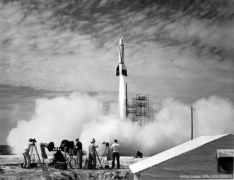
In some previous postings I have already mention the peculiar history about the V2 in this area, which launching platforms draw a huge bow from south to west around the Schoeppingen Hill. (some details and related links about the „nazi wonder weapon“ and its impact on the „Space Race“ you can find further below at the „The Sputnik of Havixbeck“ posting.
If you are interested in such topics, I highly recommend two books: „V“ and „Gravity’s Rainbow“ by Thomas Pynchon. „V“ is the title of Pynchon’s first novel, which is concerning the quest of an aging traveller named Herbert Stencil to identify and locate the mysterious entity he knows only as „V.“ – The major portion of „Gravity’s Rainbow“ takes place in the final months of the Second World War in Europe. One of the most spectacular moments in the book is „Slothrop’s „rocket-dowsing“ penis anticipates the „Blitz bomb“ hits on London with a precision that confounds statistical probability.“ Also in the best-selling 2003 novel „The da Vinci Code“ of Dan Brown – and the related film (2006), the symbolic and mystery of „V“ plays a crucial part.
If you intend to visit this area sometime, here are the coordinates of the V2-platform in the „Oer’scher Wald“ (Oer’scher Forest): N52°7’30“ E7°5’32“(no guarantee can be given about the correctness of the results)
(more…)
Kommentare deaktiviert für The Search for the Mysterious „V“
„Lost Places“ are abandoned areas or buildings – I prefer to call them ‚zones‘- which have forfeited their original importance or significance and are left to decay. But I wonder how to define such sites, if they are more or less empty or out of order, or if they are still working in a kind of symbolic mode. Such a virtual „Lost Place“ seems to be a quite mysterious launch facility in No-dong, North Korea. Before you continue, please check first the linked comment and the related satellite image(s). http://f-john.de/lostplaces/?p=58#comments
Undoubtedly Korea is a bit far away from the acquainted Schoeppingen Missile tours to be seen in this blog, but from a satellite perspective, it might be worthwhile to focus a little more on the form or shape of such structures internationally – as Klaus and I tried to bring into debate through the „cosmic key“ posting below.
Officially, the Missile Assembly Building which you can see on the mentioned satellite image concerning No-dong is supposed to contain Taepodong-2 or Taepodong-1 missiles, so-called „weapons of mass destruction“. But if you look carefully at the image(s), you will discover strange things: the paved roadway ends after a U-turn to the North of the facility, with an unpaved continuation running to the South of the facility. If you follow the related links, you will discover well researched scientific information and materials about this odd construction, such as: (…) „no railway connections, nor even paved roads connecting the launch complex with the outside world“ or „the complete absence of residential structures – as well as the complete absence of larger structures that might provide ‚industrial‘ or other operational support“.
If not planned as a futuristic tomb for the glorious dictator Kim Il-sung – what might be the purpose of such a construction? It occurs to me the whole structure is just designed to be perceived from outer space.
Kommentare deaktiviert für No-dong N40°51’17“ E129°39’58“
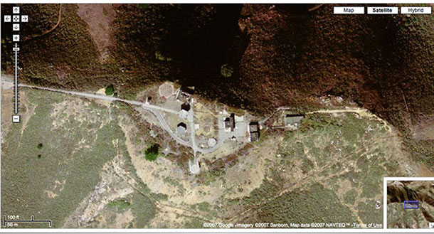
 The first posting of the new year opens a very new perspective to the project. In the following Klaus Schroll – a landscape architect – analyses a satellite image of the former anti-aircraft peak on the hill. (Please check also the referring entry from Oct. 11th.) When I
  saw the image for the first time, I was similarly surprised by the unusualness and beauty of the form, which reminded me instantly of the ancient Big Serpent Mound in Ohio. Both paths – „the serpent“ and „the key“ Klaus discovered – might be intriguing to follow. I wonder if the shape of the Nike Base indicates a hidden link between the mystery of military perception and behaviour – and phenomena occuring around the former Nike Site (Nike – Greek godess of victory). Why does the military design archetypal structures in secret areas, which are normally protected from public views, while trying at the same time to defend that territory with high-tech nuclear weapons?
Mail of Klaus Schroll, from Jan/03/2007 (extract):
(…) that stuck out to me as peculiar as soon as I saw the Aerial photograph of the Schoeppinger Berg. You know, a landscape architect has a particular way of looking things like this…
To make a contribution to your project, I have extracted the shape of the permanent track and studied it. The results bring to mind old cave paintings or symbols designed to communicate with extraterrestrials. http://antwrp.gsfc.nasa.gov/apod/ap020831.html
I have named the symbol on top of the hill „Cosmic Key“. Furthermore, the Cosmic Key lies exactly East to West. The „East-West-Line“ is well known as an ancient mystic land shape. http://www.world-mysteries.com/awr_7.htm
One last thing, there are tracks in the acres surrounding the head of the Cosmic Key that don’t seem to be there for agricultural purposes. With the high resolution image at Google-Earth, it is possible to study it very closely. It could be that there is an underground connection with Cosmic Key here…
Maybe you should look for similar structures at the „terra base“ near San Francisco.
Thanks so much for the hints, Klaus. Here you go!
This is the „terra base“ on Hill 88 near the Golden Gate. The image shows the former radar park, which was part of the defense system of the Nike Missile Site (SF-88).