Cosmic Key
 The first posting of the new year opens a very new perspective to the project. In the following Klaus Schroll – a landscape architect – analyses a satellite image of the former anti-aircraft peak on the hill. (Please check also the referring entry from Oct. 11th.) When I
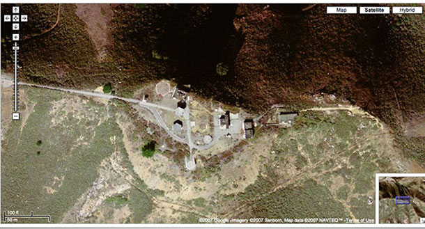
  saw the image for the first time, I was similarly surprised by the unusualness and beauty of the form, which reminded me instantly of the ancient Big Serpent Mound in Ohio. Both paths – „the serpent“ and „the key“ Klaus discovered – might be intriguing to follow. I wonder if the shape of the Nike Base indicates a hidden link between the mystery of military perception and behaviour – and phenomena occuring around the former Nike Site (Nike – Greek godess of victory). Why does the military design archetypal structures in secret areas, which are normally protected from public views, while trying at the same time to defend that territory with high-tech nuclear weapons?
Mail of Klaus Schroll, from Jan/03/2007 (extract):
(…) that stuck out to me as peculiar as soon as I saw the Aerial photograph of the Schoeppinger Berg. You know, a landscape architect has a particular way of looking things like this…
To make a contribution to your project, I have extracted the shape of the permanent track and studied it. The results bring to mind old cave paintings or symbols designed to communicate with extraterrestrials. http://antwrp.gsfc.nasa.gov/apod/ap020831.html
I have named the symbol on top of the hill „Cosmic Key“. Furthermore, the Cosmic Key lies exactly East to West. The „East-West-Line“ is well known as an ancient mystic land shape. http://www.world-mysteries.com/awr_7.htm
One last thing, there are tracks in the acres surrounding the head of the Cosmic Key that don’t seem to be there for agricultural purposes. With the high resolution image at Google-Earth, it is possible to study it very closely. It could be that there is an underground connection with Cosmic Key here…
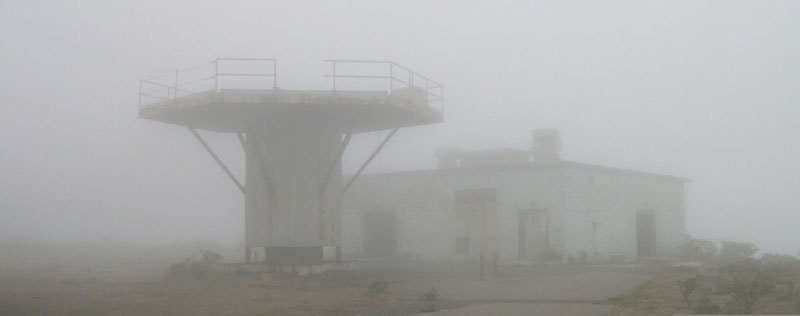
Maybe you should look for similar structures at the „terra base“ near San Francisco.
Thanks so much for the hints, Klaus. Here you go!
This is the „terra base“ on Hill 88 near the Golden Gate. The image shows the former radar park, which was part of the defense system of the Nike Missile Site (SF-88).
1 Kommentar
RSS feed for comments on this post.
Sorry, the comment form is closed at this time.
No-dong, N40°51’17“ E129°39’58“
Hallo Klaus, ich fände es spannend, den von Dir angeregten Diskurs fortzuführen, und die an archaische Zeichen erinnernden Raketenanlagen einmal global auf ihre Formen hin zu untersuchen. „Function follows form“, das wäre schon fast ein Pilotprojekt für sich – oder? Scott MacLeod, der sich des öfteren hier am Forum beteiligt hat, schickte mir kürzlich interessante Infos zu einer eigenartigen Anlage in Nordkorea. Was hältst Du davon – und wie wirken diese Formen für Dich als Landschaftsplaner?
Date: Sun, 07 Jan 2007 22:25:29 +0100; Subject: Re: Re; From: Scott MacLeod
(…) probably the architecture responds to a particular „point of view“ – „perspective“ (…)
the comment about North Korean site was: oh they say they are a threat
but look: it’s just a tin shed, a dirt road, a cement pad – ie primitive ie no threat really
http://www.fas.org/nuke/guide/dprk/facility/nodong-4.htm
http://www.fas.org/nuke/guide/dprk/facility/nodong.htm
Das verrückteste an der No-dong-Anlage ist, sie wurde von vorneherein mit unbeschreiblichen Aufwand als ein „Lost Place“ angelegt – also ohne erkennbaren praktischen Nutzen, bestenfalls für Blicke aus grosser Höhe – z.B. aus dem All – konzipiert. (s. obige Links aus dem Forum der Federation of American Scientists). – Ein weiterer kommunistisch-surrealer Akt? Oder handelt es sich um moderne Geoglyphen, die ähnlich den Nasca-Linien in Peru alleine unter logischen bzw. rationalen Gesichtspunkten kaum zu entschlüsseln sind? Der zugehörige Wikipedia- Link zu Nasca – Däniken lässt grüssen – ist hierzu ebenfalls interessant.
Hello Klaus, I found it exciting to pick up on your stimulating discourse and to research MIssile bases resembing archaic symbols on a global scale. „Function follows form“, that was already nearly a pilot project for you, wasn’t it? Scott McLeod, who has often contributed to this forum, recently sent me some interesting information regarding an odd site in North Korea. What do you notice, from your perspective as a Landscape architect?
Date: Sun, 07 Jan 2007 22:25:29 +0100; Subject: Re: Re; From: Scott MacLeod
(…) probably the architecture responds to a particular „point of view“ – „perspective“ (…)
the comment about North Korean site was: oh they say they are a threat
but look: it’s just a tin shed, a dirt road, a cement pad – ie primitive ie no threat really
http://www.fas.org/nuke/guide/dprk/facility/nodong-4.htm
http://www.fas.org/nuke/guide/dprk/facility/nodong.htm
The most peculiar thing about the site is, that it is a Lost PLace in every sense possible: it was designed with no recognisable practical use, at best conceived for views from above – for instance from space. (please check also the up mentioned links from the Association of American Scientists) Or has it more to do with modern geoglyphs like the Nasca Lines in Peru, which can´t be decoded alone under logical and rational considerations? The corresponding wikipedia link to Nasca – Daniken says hello – is very interesting regarding this.
annotation: in this context terms like Geomancy might be interesting to be discussed as well.
Kommentar by Franz John — Sonntag, Januar 21, 2007 @ 13:55