Skulptur-Biennale Münsterland 2005
An 80kms sight-specific installation between the cities of Gronau and Bocholt (public art).
Münsterland, Germany, since 2005 (unlimited)


The project Salztangente (Salt Axis) that emerged as part of the framework of the Skulptur Biennale Münsterland engaged – similar like Turing Tables – with a geological visualization problem, in this case referring not to a »now« constructed by current data as real time, but a hardly conceivable time frame of two hundred million years.
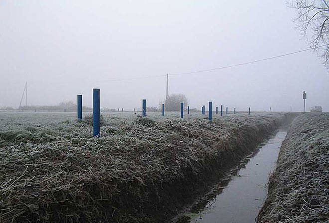
In Borken District, Münsterland, there is a large set of subterrestrial salt deposits that have been significant for this region in terms of both geological and cultural history. Along an 80-kilometer axis, marked as a bike path, Franz John has constructed several fields with rods of an average height of three meters; these rods indicate the former depth of the «primeval sea» that dried up long ago, responsible for the salt deposits, replaced by a «cultural landscape» that defines itself in part by way of its use of the salt.

In this way, bicyclists can in a sense place themselves in an imagined underwater space, but also an entirely «experienceable» space of history, whereby the colored markings are indexed using a scale between blue and grey based on geological maps, indicating the thickness of the salt deposits in the respective site.
Despite appearing similar in a formal sense, there is here an imaginably immense contrast to the Land Art experiments from the 1960s and 1970s, for central to Franz John’s work is the moment of mediacy between abstract knowledge and individual experience.
Text by Clemens Krümmel
related project info:
Franz John – Die Salztangente (refering project website with GPS-coordinates)
kunstaspekte.de: Skulptur-Biennale Münsterland 2005
NRW-Skulpture Guide: Franz John – Die Salztangente
Franz John – Die Salztangente | catalog with info and bikemaps
(ed.) Kreis Borken – Kulturamt, ISBN 3-937432-09-4